

.jpg)
About Gallery of Maps
Explore Gallery of Maps

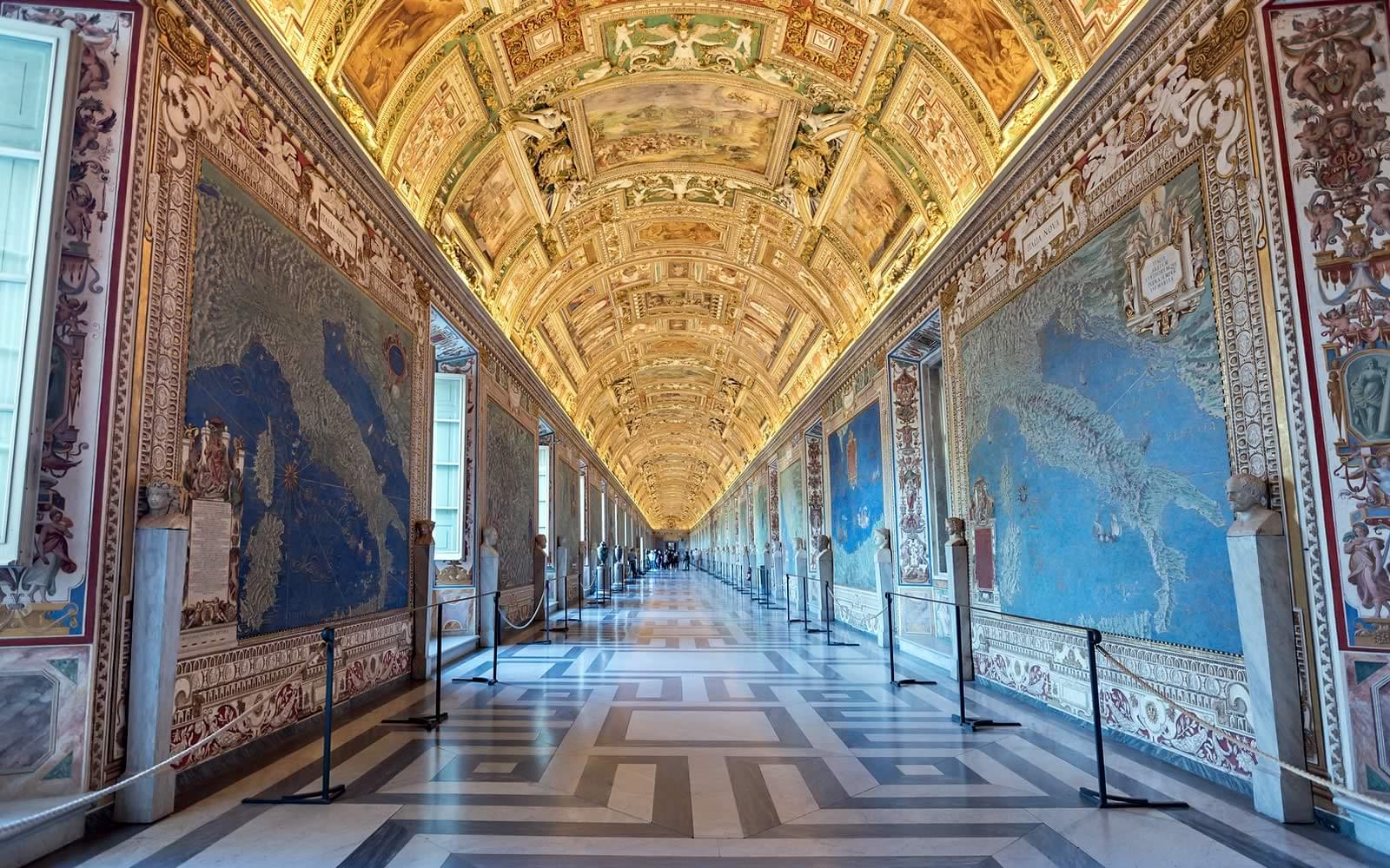
The Gallery of Maps was commissioned by Pope Gregory XIII in the late 16th century, as part of his efforts to decorate the Vatican Palace with grandiose works of art. The gallery was designed by architect Ignazio Danti and took three years to complete.
Must Read: History Of Rome

The Gallery of Maps is a long, narrow corridor that stretches for 120 meters, with 40 maps lining the walls on either side. The ceiling of the gallery is adorned with frescoes depicting various events from the life of Pope Gregory XIII.

The maps themselves are the highlight of the gallery, each one measuring 4.5 meters by 3.5 meters and featuring intricate details of Italy's regions, cities, and landscapes. The maps were created by a team of topographical experts and took several years to complete.

The maps were not just intended to be works of art; they were also political statements. They were created at a time when Italy was divided into multiple states, and the maps were designed to highlight the power and influence of the Catholic Church over these regions.
Suggested Read: Churches in Rome

The maps were created using a combination of cartography, geography, and artistry. They were drawn using pen and ink, and then painted with watercolors to create vivid, lifelike images of Italy's landscapes and cities.

The maps in the Gallery of Maps are an excellent example of the influence of Renaissance art on cartography. They incorporate many elements of Renaissance art, including perspective, shading, and realistic depictions of people and animals.

Over the years, the Gallery of Maps has suffered damage from humidity, pollution, and other environmental factors. In the 1990s, a major restoration project was undertaken to repair the damage and preserve the maps for future generations.
Must Read: History Of Roman Catacombs

The Gallery of Maps is not just a beautiful work of art; it is also an important historical document that provides insights into the geography and politics of Italy during the late 16th century. It is a testament to the power of the Catholic Church during this time and a reminder of the enduring importance of art in preserving and communicating history.

The Gallery of Maps is a popular destination for visitors to the Vatican Museums and is typically included in guided tours of the complex. Visitors are encouraged to take their time and admire the intricate details of the maps, as well as the stunning frescoes on the ceiling. The gallery is also wheelchair accessible.
Must Read: Parks In Rome
Know Before You Go

Location: The Gallery of Maps, or Galleria delle Carte Geografiche, is located within the Vatican Museums in Vatican City, Rome.
The museum showcases a stunning collection of map frescoes depicting regions of Italy painted in the 16th century.
Opening Hours: The Gallery of Maps follows the same timings as the Vatican Museums, open from Monday to Saturday, 9:00 AM to 6:00 PM, closed on Sundays and major holidays.
Best Time to Visit: The best time to visit the Gallery of Maps is during weekdays, preferably in the morning, to avoid larger crowds.
Also Read: Best Time to Visit Rome

Metro: Take Line A of the Rome Metro and get off at the Ottaviano-S. Pietro station. From there, it's a short 10-minute walk to the Vatican Museums, where the Gallery of Maps is situated.
Bus: Several bus lines have stops near the Vatican Museums. Check the local bus schedules and routes to find a bus that takes you close to the museum. Consult a map or ask locals for assistance in locating the nearest bus stop.
Taxi: Taxis are widely available in Rome. Hail a taxi or visit a designated taxi stand and inform the driver that you want to go to the Vatican Museums. They will drop you off at the entrance, where you can access the Gallery of Maps.
Walking: If you are in the vicinity of Vatican City, you can also reach the Gallery of Maps by walking. Follow the signs leading to the Vatican Museums, and you will find the entrance to the museum complex.
Suggested Read: Interesting Facts About Roman Forum

FAQs
What is the Gallery of Maps?
The Gallery of Maps is a stunning hallway located within the Vatican's Apostolic Palace. It features a series of maps painted on the walls depicting the Italian regions and the papal territories, commissioned by Pope Gregory XIII in the 16th century. The gallery is renowned for its intricate details, vivid colors, and impressive size.
How long did it take to create the maps?
The maps in the Gallery of Maps were created over a period of several years, beginning in 1580 and continuing until 1585. The project was overseen by a team of skilled cartographers and artists, who worked tirelessly to create the detailed maps that adorn the gallery's walls.
Suggested Read: St. Peter's Basilica Events
What is the purpose of the Gallery of Maps?
The Gallery of Maps was commissioned by Pope Gregory XIII as a way to celebrate the papal territories and showcase the beauty of Italy. The maps were designed to be both informative and visually stunning, allowing visitors to appreciate the rich history and geography of the region.
How were the maps created?
The maps in the Gallery of Maps were painted on the walls using a fresco technique, which involves applying pigments to wet plaster. The artists used a variety of colors and techniques to create the intricate details and vivid scenes depicted on the maps.
What are some of the most notable maps in the gallery?
There are 40 maps in the Gallery of Maps, each depicting a different region of Italy or the papal territories. Some of the most notable maps include those of Rome, Venice, and Naples, which feature detailed depictions of the cities' landmarks and architectural marvels. The map of the Marche region is also particularly impressive, as it features a panoramic view of the region's mountains and coastline.
How can I visit the Gallery of Maps?
The Gallery of Maps is open to visitors as part of the Vatican Museums complex. Visitors can purchase tickets online or at the entrance to the museums. It is recommended to book tickets in advance to avoid long lines. The gallery is located on the way to the Sistine Chapel and is included in the standard Vatican Museums tour. Visitors can spend as much time as they want to admire the intricate details of the maps and learn about their history and significance.
Know the ways to skip the line at St. Peter's Basilica
Which are the most popular attractions in Rome that I can book through MyRomePass?